Location: East Acton, parallel to northern side of Route 2, 0.8 mile west of rotary at MCI in Concord
Terrain/Trail Conditions: Gentle sloping dirt trails with dense forest canopy and a few wet spots through a vernal pool complex; partly wide trails due to an old cart path
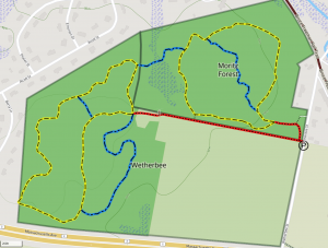
Loop trail: .8 mile
Acreage: 33
Entrances:
- West side of Wetherbee St; trailhead shared with Wetherbee Conservation Land; follow Red trail onto 35 Wetherbee St traveling through pine trees into a grassy open space
- Multiple trail access points along Red trail adjacent to farm field
- Kiosk at trailhead in grassy open space
- Parking at roadside; along Wetherbee St shoulder; shares parking with Wetherbee Conservation Land
The Clement and Elizabeth A. Moritz Forest Conservation Land was opened to the public in the summer of 2025 after being approved at the Fall 2024 Special Town Meeting. The acquisition of the land was made possible thanks to the Community Preservation Committee, the Commonwealth’s Executive Office of Energy and Environmental Affairs’ LAND Grant, and donations from 2 local land trusts: the Sudbury Valley of Trustees (SVT) and Acton Conservation Trust (ACT). A Conservation Restriction has been placed on the entire 33 acres and is held by SVT in perpetuity.
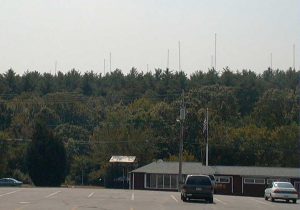
Prior to the land’s public ownership, it’s 33.11 acres of woodland and wetlands was comprised of 2 parcels that belonged to the Moritz family for farming, recreation, and an amateur radio operation. Clement Moritz was an avid amateur radio enthusiast and installed nineteen 140-foot tall radio towers that could be seen as from as far as Route 2 and Great Road. These towers helped Clement, radio license W1EVT, make contact with other operators and broadcast communications far and wide whether it be for recreation or emergency purposes. The towers were removed in 2025 after years of enduring harsh weather and falling into disrepair. Evidence of where the towers once stood can still be seen along the trail (which was previously old paths used to access the towers for maintenance).
The trail system is located on both parcels beginning at the Wetherbee Conservation Land trailhead and proceeding onto a Red Trail through mixed pine and oak trees onto 35 Wetherbee St. The Red Trails comes out to a grassy picnic area that used to be the site of the former dwelling and family gardens. The Red trail continues into the pine forest and approaches a fork for a Yellow Trail Loop. Following the Yellow Trail Loop clockwise, the trail continues along an old farm path that runs parallel to the farm field and Red trail on Wetherbee Conservation Land with 2 additional trail connections. The Yellow Trail turns Northwest and crosses an elevated path between two large vernal pools. The Yellow Trail continues to gradually incline and catches up with a Blue Connection Trail that goes West to Wetherbee Conservation Land. The Yellow Trail continues around former sites of the radio towers and intersects with another Blue Trail that could be taken as a short-cut back to the trailhead on Wetherbee St. This Blue Trail is significantly wide (6 ft) as a result of the access needed to remove the radio towers. The Yellow Trail continues through a portion of young pine forest and runs parallel to lots located on Horseshoe Dr. The Yellow Trail begins to descend gradually and follows an old stonewall complimented by large portions of ferns on either side. The Yellow Trail finally loops back around leaving the stonewall and sloping upwards to meet back with the Blue trail short-cut and Yellow Trail intersection. Following the Yellow Trail Southeast leads to the trailhead, kiosk, and grassy open space picnic area.
Notable features and habitats of the land include a robust interconnected vernal pool complex and a second-growth mixed coniferous and deciduous forest with mature eastern white pine, oak, and swamp maple. The ecosystem supports diverse wildlife, including coyotes, white-tailed deer, various bird species, reptiles, and amphibians like the State-listed Wood Turtle and salamanders. The properties contain two Massachusetts Division of Fish and Wildlife certified vernal pools and several potential ones, which interconnect during high water, enhancing their ecological significance. A historic stone-lined natural spring offers a unique feature of the property; highlighting it’s agricultural past.
To read more about the species, features, and conservation value of the land Click Here – Oxbow Voluntary Species Assessment
In addition to walking and hiking, the land can be used for cross-country skiing, horseback riding, snowshoeing, and tracking/birding. In the future, the grassy picnic area may have additional picnic tables and benches added.
A connecting trail to the Bruce Freeman Rail Trail is still in the works and will be included as soon as it is complete.